
Japan Protests New UN-Backed World Map Over Kuril Islands Depiction
Japan has asked for a correction to a new Equal Earth world map after the disputed Kuril Islands were shown in the same colour as Russia, raising territorial concerns.
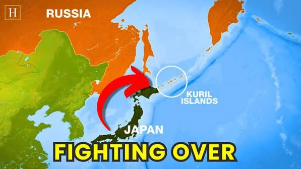
Japan Protests New UN-Backed World Map Over Kuril Islands Depiction
Japan has protested the depiction of the disputed Kuril Islands on a new world map endorsed by the United Nations, arguing that the presentation could create a misleading impression about the country's territorial claims.
Japan supported the UN General Assembly resolution encouraging the use of the Equal Earth projection, but the government has objected to a specific map published by the projection's developers because the four southern Kuril Islands claimed by Japan are shown in the same colour as Russia.
Chief Cabinet Secretary Minoru Kihara said on September 10 that Japan had contacted the operator of the website through diplomatic channels and requested that the depiction be corrected. He said Tokyo needed to prevent misconceptions about Japanese territory and geographical names from spreading.
Why the New World Map Is Controversial
The Equal Earth projection has attracted international attention because it represents the relative size of continents more accurately than the widely used Mercator projection.
The UN General Assembly approved a resolution on September 4 encouraging member states to use maps that provide a more accurate representation of land areas. The measure was supported by 164 countries, while the United States voted against it and six countries abstained. The resolution is non-binding and does not require every country or map provider to abandon the Mercator projection.
The main objective is geographic accuracy. On traditional Mercator maps, areas closer to the poles appear disproportionately large, making Europe and North America look much bigger relative to equatorial regions such as Africa.
Equal Earth, developed in 2018, is an equal-area projection designed to preserve the relative size of landmasses more accurately. However, the projection itself does not determine sovereignty over disputed territories.
What Japan Objected To
The controversy arose from the way the Equal Earth map currently displayed the disputed islands.
The four islands that Japan calls the Northern Territories were shown in the same colour as Russia, which Tokyo says conflicts with the Japanese government's position on the sovereignty dispute.
Japan maintains that the four islands — Iturup, Kunashir, Shikotan and the Habomai islets — are part of Japanese territory. Russia has controlled them since the final stages of World War II and rejects Japan's territorial claim.
Japanese officials stressed that the UN resolution supporting an equal-area map should not be interpreted as endorsing the specific political or territorial markings used on any particular map. Japan's government has made a similar point regarding the country's territorial representation in discussions surrounding the UN-backed map initiative.
Map Developers Respond
The developers of the Equal Earth projection have indicated that the Japanese-language version of the map could be changed to address the issue.
Japanese broadcaster FNN reported that co-developer Tom Patterson told the outlet that the colour of the disputed islands could be changed in the Japanese version, while the English-language version could remain unchanged.
That distinction highlights an important issue surrounding politically sensitive maps: cartographic design and territorial representation can have different interpretations depending on the audience and the conventions used to identify disputed areas.
The Kuril Islands Dispute
The territorial dispute dates back to the final days of World War II, when Soviet forces seized the islands and the Japanese population was subsequently expelled.
The dispute has remained one of the major obstacles to a formal peace treaty between Japan and Russia following World War II.
Relations have deteriorated further in recent years because of Russia's war in Ukraine and Japan's alignment with Western sanctions against Moscow.
The territorial dispute also resurfaced prominently after Russian President Vladimir Putin visited the disputed islands in August. Japan condemned the visit and reiterated that the Northern Territories were an inherent part of Japanese territory. Moscow rejected Tokyo's position as legally unfounded.
The latest map controversy therefore comes at a particularly sensitive moment in Japan-Russia relations.
The Map Does Not Change Sovereignty
Despite the political reaction, the Equal Earth map itself has no legal power to determine territorial ownership.
The UN resolution is aimed at improving the representation of geographical areas and encouraging wider use of equal-area mapping. It does not transfer sovereignty over disputed territories or legally recognize Russia's claim to the Kuril Islands.
The UN's decision was primarily driven by concerns about how conventional map projections represent the size of continents. The Equal Earth projection makes Africa appear substantially larger relative to Europe and North America, addressing distortions inherent in the Mercator projection.
Why the Equal Earth Projection Matters
The controversy over the Kuril Islands is separate from the scientific reason behind the map's adoption.
Mercator was developed in the 16th century primarily for navigation. Its ability to preserve directions made it extremely useful for maritime purposes, but it distorts the apparent size of land areas, particularly toward the poles.
Equal Earth takes a different approach by preserving area relationships. As a result, Africa is shown closer to its actual relative size, while Europe and North America appear smaller than they do on familiar Mercator maps.
The UN resolution encourages wider use of more accurate representations but does not prohibit other projections. Mercator remains useful for navigation, while different projections can be appropriate for different purposes.
Key Takeaways
- Japan has protested the map: Tokyo objected to the disputed Kuril Islands being shown in the same colour as Russia.
- Japan supported the UN resolution: The country backed the initiative promoting more accurate equal-area mapping.
- The UN resolution is non-binding: It encourages the use of Equal Earth and similar projections but does not impose a single mandatory map.
- The map does not decide sovereignty: The colouring of disputed territories has no legal effect on ownership claims.
- The Kuril dispute remains unresolved: Japan claims the four southern islands, while Russia has maintained control since 1945.
- The projection is mainly about geographic accuracy: Equal Earth corrects the size distortion associated with the traditional Mercator projection.
Why This Matters
The dispute demonstrates how even a seemingly technical change in cartography can have diplomatic consequences when maps include territories claimed by more than one country.
Japan's objection is not directed at the Equal Earth projection itself. Tokyo supported the UN resolution but wants disputed territory to be represented in a way that does not, in its view, undermine Japan's official position.
The episode also illustrates the difference between map projection and territorial sovereignty. Equal Earth changes how the world's landmasses are visually represented; it does not determine which country legally owns a disputed territory.
For Japan and Russia, however, the Kuril Islands remain a highly sensitive issue. With bilateral relations already strained, even the colouring and labelling of the islands on an internationally promoted map has become a matter of diplomatic concern.
More Stories
Russian Drone Strike Hits Indian Pharma Plant in Ukraine Again, One Killed
5 Oct 2026
Trump Rolls Out Grand Welcome for Xi Jinping as US-China Talks Face Tensions Over Trade, Taiwan and Iran
23 Sept 2026
Sri Lanka Easter Bombings Verdict: Court Set to Rule on 24 Accused in 2019 Attacks
22 Sept 2026

Pakistan Mosque Blast: 21 Killed, 15 Police Officers Among Victims in Kohat Suicide Attack
18 Sept 2026